|
Return
to Site Map
|
WALK to
CESSAC and
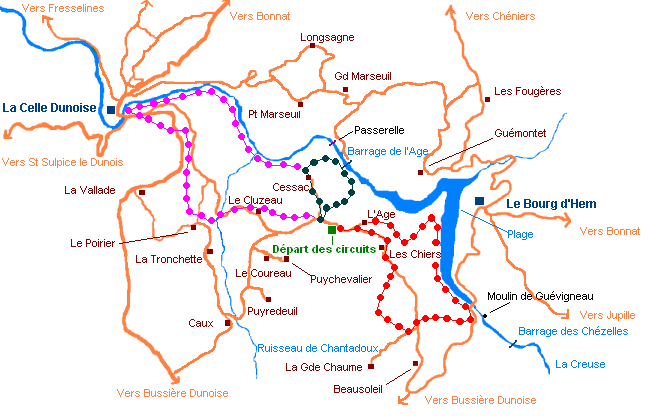
Age dam - 1h30 - Departure from L'Ecole Buissonniere
1) The Cessac hamlet, and
others in the surrounding area show very ancient
inhabitation of the Creuse valley . Indeed, place names including
the sound
"ac" were generally occupied
during the Gallo-Roman or Franque period. Mention of Cessac is found
towards 1437: it would have been the property
of a Gallo-Roman, Cissus.
2) At the exit of Cessac, just
before going down towards the Creuse river, stop a moment to admire,
on your right side, this beautiful
old stone cross dating, probably, from the XVIth
century. The hamlet used to have a specific funerary custom: before the procession left to go to the village and
the cemetery, people used to break the holy water bowl,
which had been at the bedside of the deacesed, on the cross. This custom was preserved until
the beginning of the XXth century. To continue the Cessac walk,
it is necessary to leave the broad and pleasant path, and to take,
on the right, the narrow sloping path which curves between the trees.
(Note that if you stay on the left side track , you will join the
Fanaud Walk, described further). While going down towards the
river, you will notice some imposing rocks giving the landscape
a "solemn" character, and sheltering in their anfractuosities
capillary ferns and "Venus
navels".
3) After the wood, the path
leads to a more open space. On the right, you will see a field of ferns, so homogeneous
that it would appear to be cultivated. In fact, it is not surprising : ferns are plants which need very nitrogenized ground,
this is why they are readily established on old land which is
no longer cultivated but which was regularly manured over
a long period.
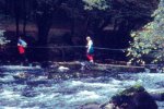
4) You will discover the river with a metal bridge
downstream crossing the Creuse and, upstream,
the Age dam. You are
on the territory of many animals living close to the water.
If you are quiet you will surely see the
dipper or "water blackbird" whose characteristic
is to go to the bed of the river, even in running water, to eat
the watery larvae fixed on the bottom stones.
5) The Age
dam was brought into service in 1982. It is a spillway type work
, with multiple vaults, a score of meters high. It is in the
site that local people called "Gour
Jonchère", right at the exit
of the old and wild hemmed gorges where,
formerly, the Creuse river ran as a tumultuous torrent and dug impressive
pits (a "gour" means a deep hole in a river).
While
climbing the slope which leads to the top of the work, you will
smell the fascinating odor of
boxwood. The presence of this shrub is also a sign
of the old Gallo-Roman inhabitation. Moreover, the boxwood feast, traditional
in Cessac derives from
these times.
6) You are now overhang the Age reservoir
the construction of which was followed by two other hydro-electric
installations giving rise to the 3 Lakes'
Country. In the path which continues to rise
coming
back to L'Ecole Buissonniere, you will find one of the best blackberries
plots in the area, and if by chance, you are there in September to
collect them, do so 1 meter high of the ground to avoid the
urine that the fox deposits
to mark its territory which can cause disease.
7) On
return to the plateau, you will find the bocage landscape with its
meadows and fields intersected with dry stone walls or hedges. Both
frequently shelter the weasel, the
smallest of Europe's carnivores.
Return
to the walking tours map
WALK
of the MILLS - 2h30 - Departure
from L'Ecole Buissonniere
1) The first
village you pass is called L'Age,
l'Ecole Buissonniere and the hydro-electric reservoir, are attached
to this hamlet. This name is certainly one of the most widespread
in the Creuse departement (46 examples !) and in
the Middle Ages indicated a defensive fence.
2) To join
the lake you take a very beautiful wooded track, often bordered with
dry stones evoking rural
areas patiently built and, today, deserted. Indeed, you will find
there, an example of what the archaeologists call "banks",
which means careful stacking of stones which the peasant found in
the middle of his land on the edge of the property. It had
two purposes: to clean the ground of course, and to delimit the property,
but also, in the sloping lands of the valley, to retain the ground
by creating terraces.
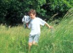
In the freshness of this beginning of
the walk, you may hear, in spring, the characteristic whistle of
the Europe's oriole which
resembles a human one, or the wing flaps of the turtle-dove or the
wood pigeon that you have caused
to flee.
3) You are now at the edge of the water, on the Age reservoir,
in front of the beach of Le Bourg d'Hem.
And you can now congratulate yourself on having choosen
this walk, allowing you to enjoy this unusual view of this large
meander that the river draws in a strategic place, at the confluence
of the Creuse river and Combrand's
brook. And up hill, on its spur, the bell-tower of
Bourg d'Hem's church, just overlooking the trees will seem so far
that you will understand how appropriate the
name Creuse - from the Gallic Chroso,
which means "hollow" really is.
4) Very
beautiful path following the banks of the lake to the bridge of Le Bourg d'Hem.
Do not forget to admire, above you, the prowesses of
the flight of the busards or the black kites, and try to recognize
them. Note also, according to the seasons, the abundance of purple fox gloves, "germandrées" and other
ground covering plants as well as the ground
ivy or honey suckle. Also look
for the beautiful pink gneiss rocks
whose
cavities could accommodate a genet
in search of a home.
5) Here is the Bourg d'Hem's
bridge . Rest a moment while observing, on the emerging stones,
the jumps and ceaseless play of
the grey wagtail by the water fall of
Guévigneau's old mill which
formerly constituted a crossing point through the Creuse river
to join the village of Le Vignaud.
6) After coming back
to the plateau, you will head towards "La
Grande Chaume", perhaps the most isolated hamlet
(there is only one house!) of the commune with, all around, very
wild moor land. The "Saint
Martin" hen-harriers
enjoy
sleeping here, that's why it
is so quiet!
7) This kind of path, bordering fields and
woods is a perfect place to surprise the
roe-deer which is common
in our area. Note the
presence of beautiful beeches
on this part of the tour. So, how do you distinguish the beech's
leaf from the hornbeam's one ? (2 "Table d'Hôtes"
meals offered for the first correct answer sent by e-mail !)
8)
Now, you have to follow this broad and beautiful track to come back
to the hamlet
of "Les Chiers "
In fact, the etymology of the word comes from "rock",
a root-name we can find in several other communes of the Creuse. And
indeed, you are in the highest hamlet of La Celle Dunoise,
367 meters high, precisely.
Return
to the walking tours map
FANAUD
WALK- 2h30 - Departure from L'Ecole Buissonniere
1) The walk starts like the Cessac
one
but after having crossed the hamlet, remain on the very beautiful
track which goes down towards the river, in this way you will reach
La Celle Dunoise by the bottom of the
valley. In this very beautiful timbered path, paradise
for passerines (nuthaches and climbers)
reign, as a Master, the sparrowhawk,
birds of prey able to fly underwood to surprise its preys after amazing
arabesques between the trees.
2) You will pass a pretty
small stone bridge overgrown with ivy and honey suckle and
you will follow the
brook of Chantadoux on your right.
3) The
elms are splendid trees which were decimated in France
by a disease called the "graphiose"(dutch elm disease).
In certain places, we don't know why, they resisted and survived.
You will find a beautiful specimen of this tree in the confluence
of the brook of Chantadoux and the Creuse river.
4) At
this place, begins the millcourse of an
old mill , Fanaud, whose mill dam was carried away
by a flood in 1937. The mill buildings are in ruins today,
but they had a significant function because the mill was transformed
into an electric plant and
was used as a power station for 22 years, from 1911 to 1933.
The Fanaud electric power station provided electricity to five
of the largest communes of the sector: St Vaury, Bussière
Dunoise, La Celle Dunoise, St Sulpice le Dunois and Dun le Palestel.
Very close to the mill, there is a dwelling house of which
only the stone staircase remains in the tangle of vegetation. The last person
who lived there received the nickname of "La Fanaude".
5) Before approaching the straight path which leads to La Celle
Dunoise, the river draws a pronounced meander, crashing into a rock
that form a bottleneck where the water bubbles iwhen it rises.
It is the "boxwood ford"
: at that place it was possible to cross the river, before the
creation, in the Middle Ages, of the mill of La Celle Dunoise.
6) If you are interested in fauna and flora, you will
find one of the most picturesque paths with : oaks,
alders, maples, limes, hornbeam for the trees; inulas with willow's leaves, lathrées clandestine and lysimaques
for the plants; wrens, kingfishers
and green woodpeckers for the birds. Without forgetting
this mythical animal, the supreme symbol of preserved nature
the otter. Of
course, it's quite impossible to see it but notice that its presence
can be detected by identification of its "épreinte"?
(name given to the droppings which are made to
mark its territory).
7) You arrive in La Celle Dunoise
borough, as soon as you pass along the old mill dam and the summer canoe-kayak base.
8) After having had a look in the village (and bought the bread
for which you came !) you will go up towards L'Ecole Buissonniere
by taking the sunken lane, parallel with the road to Bussière
Dunoise. Here is another place where the diversity of the fruitshrubs
which border the path will surprise you (brambles,
dogwoods, elder trees, holly, hazel trees) and knowing
how much the birds are fond of their fruits, you will understand
the presence of so many tits (blue,
coal, with black head, with long tail, ...)
9) You will pass not far from Le Poirier
hamlet and will continue on
another shaded path which
will bring you back to the small valley of the Chantadoux brook.
Do not miss, on the edge, this beautiful beech with a gray and smooth
bark because they are rare in our sector, preferring higher altitude
zones.
10) After a beautiful common
maple hedge,
you will immediately find the brook of Chantadoux which draws, downstream
to the bridge, splendid waterfalls in spring when the water is strong.
It is here that you can hear, depending on the seasons, the beautiful
nightingale song at dusk.
11) At Le
Cluzeau, you will leave the road to take the last
path of this pretty pedestrian route which will bring you back close
to L'Ecole Buissonniere, at the crossing of the road of Cessac.
Cluzeau comes
from clusellum (closed) and there are ten inhabited
places in the Creuse, with this name. The toponym often indicates
underground. This path, sometimes vbecomes ery wet because of many sources,
worth the trip in spring when buttercups,
forgets-me-not, stellar and colombines are in flower.
|
Top
of the page
|