|
Return
to Site Map
|
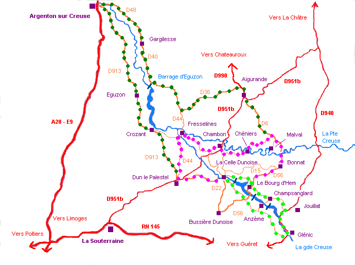
The Country of the 3 Lakes' tour
For a general
presentation, refer to > Le
Pays des 3 Lacs
In addition,
here is a description of each relevant commune- from downstream to upstream
- with their poles of interest:
La
Celle Dunoise
Commune of
approximately 600 inhabitants - altitude of the village: 232 meters
at the bridge - origin of the name: cella 1154, prior of cella 1216, the Latin word indicates an isolated house inhabited
by a monk or a habitation for a group of monks depending on an
abbey.
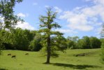
* very picturesque village nested in the hollow
of the valley, with houses rising in tiers on both sides of the river.
* XIIth
century church listed as a historic building. The capitals of the choirs are carved with animals
and it's vault is covered with paintings from 1879.
* close to
the church, "the
stone of deaths" is a "cippe" of the Gallo-Roman period.
* XIVth century
bridge on the Creuse river, which has preserved its original central part in
form of rib.
* waterfalls at "Gour enfariné",
Touérat, Pisserotte.
* old mill dams and mills.
*
the Age dam, which caused the creation of the 1st lake.
Le Bourg d'Hem
Commune of approximately 250 inhabitants -
altitude of the village: 340meters - origin of the name: hent 1256, ahento 1282, the
etymology is a Gallic word indicating a height.
* village built on a spur site of the
confluence dominating the Creuse
valley .
* panorama from the church's square overhanging the river
and the old antique path bordered with hundred year old boxwood which joins the strategic
hamlet of "Guémontet".
* XIIth century church
in a listed site,
splendid traditional roofing of chestnut
shingles.
* bronze stele set up
in memory of Pierre
Maillaud, also known as "Bourdan",
journalist of the Voice of Free France.
* "Fougères"
hamlet , resting and working place of the historian Marc Bloch
(1886 - 1944).
* Villebaston
castle listed since 1926.
* site
of "La Roche Gallet", known as "Jupille rock"
in the heart of the sheer gorges of the Creuse river.
* the
Chézelles dam, which caused the creation of the 2nd lake.
Anzème
Commune of approximately 500 inhabitants - altitude
of the village: 330 meters - origin of the name: ancesime, 1031-1033,
anzismensi ecclesia, 1108, of the Celtic radical anco which means bent, the site overhangs sharp meanders.
* panorama of the church's square, beautiful view over the Creuse
meanders.
* XIIIth century church
listed as a historic building, remarkable XVIIth century carved and painted reredos, stone
sculptures of the capitals.
* ogival bridge with
only one arch, known as "the
Devil Bridge" of which the old
part dates from the XIVth century, popular legend attached to this
work.
* waterfalls at "Les Moulines", in a typical
moor landscape with birches, gorses and heathers.
* remarkable
granite crosses.
Return
to the tourist tour map
Champsanglard
Commune of approximately 200 inhabitants
- altitude of the village: 400 meters - origin of the name: campus singularis,
not dated, can indicate, in Latin, a space cultivated in the middle
of fallow lands.
* village with agricultural vocation with
a lot of quickset hedges
characteristic of the bocage landscape.
* Lasvy castle with its chapel and its tiled square towers with slate
turrets.
* antique
path, between the Devil Bridge and the
hamlet of Vaillonnat, splendid paving stones.
* Champsanglard's
dam, at the height of the hamlet of Chambon, it is the last to be
built.
Jouillat
Commune of approximately
350 inhabitants - altitude of the village: 390 meters - origin of
the name: ajuliaco, 1019, joellac, joula, 1202, joulhac, XIVeme, indicate the field of Jules.
* XIIth and XIIIth century
church,
listed as a historic building.
Recently, superb and admirably preserved frescos were discovered
and restored.
* listed
XVth century castle, imposing
rectangular basic volume flanked with four round angle towers and
crenellated machicolation.
* multitude of hamlets whose names
start with "ville", revealing the existence of antique exploitations
(villas).
* zone of the
"Croissant", on the
limit of the Oc and
Oil languages.
Glénic
Commune
of approximately 600 inhabitants - altitude of the village: 360
meters - origin of the name: glanic, 1150, 1184, from glenico, 1332, of the Gallic glann, bank of a valley.
* village dominating the
valley from the top of a rocky peak, old village with defensive
vocation where we can find, as for Anzème and Le Bourg d'Hem,
a layout of houses around the central square.
* church dating from the end of the XIth
century, listed historic building,
reworked and fortified during the Hundred Year's War.
* imposing
railway viaduct, formerly on the line of La Châtre- Guéret.
Return
to the tourist tour map
The Valley of La Petite Creuse tour
For an
introduction to the
most representative sites, refer to Fresselines
In addition
here are three other places worthy of interest:
Bonnat
This main town to which the commune
of Le Bourg d'Hem is attached, is distinguished by its church and its
castles. The first, built in the XIIIth century, was fortified thereafter,
the gate is decorated
with beautiful sculptures and stained
glass dating from the XIXth century. Three castles deserve a glance:
that of Grandsagne on the Le Bourg d'Hem
road, traditional style with
beautiful proportions; that of Beauvais, on the Champsanglard
road, and especially the
estate of Mornay (XVth and XVIth centuries) on the Châtelus
Malvaleix road, transformed into a reception center and a racing circuit.
The Malval castle
Malval is the name of a very small
hamlet close to Bonnat where there are ruins of a fortified castle built in
about the year 1000, itself built on an older "castral mound". This castle played a role in the history of La Marche,
in particular in 1370 when DuGuesclin stayed there. It retains
few aspects of that building,
except the old drawbridge lost in the vegetation and two dilapidated
towers. However, the site at the edge of La Petite Creuse retains
a romantic and solemn character. You will enjoy a visit to the Sainte Valerie church
dating from
the XIIth century, a
remarkable example
of a fortified church with its
bell-tower-keep.
Chéniers and the Pouligny tile works
The Chéniers village has a very beautiful XIIth century
church with a XIII
or XIVth century bell-tower-porch, decorated with carved capitals. In the commune,
on the Le Bourg d'Hem road, there are several old tile works,
vestiges of a significant local artisanal activity: the manufacture of tiles and bricks. Those of Pouligny which is today
enjoying a revival thanks to the restoration
of the old buildings, testifies to the efforts of a family which,
for 5 generations, worked there from 1830 to 1961. An ambitious
project is under development and the site can already be visited
and has become a place for meetings, exhibitions and exchanges related
to clay work. You will appreciate the beauty of the place, on
the edge of a wood, and the quality of the restoration of these
buildings with a very
unusual architecture : the roofs
with 4 slopes to the ground, no walls and the layout
of the tiles helps the air to circulate inside to dry the pottery
before firing.
Return
to the tourist tour map
The Valley of La Grande Creuse tour
The most significant sites
have already been introduced, refer to
> Crozant
> Eguzon
> Gargilesse
Here is, in addition the description of two
other localities you will cross:
Argenton
sur Creuse
This small pretty
city
on the edge of the Creuse river is the farthest point of the tour, at about a
1h30 car drive from L'Ecole Buissonniere. But you
won't regret the detour : it's
old medieval areas, its galleries overhanging the river, its
mills with wheels and its monuments
are some of the points of interest which will help you to enjoy an excellent
day. You will admire, in particular, the private mansion
of the Duperthuis street (XVth century), the old hotel of Scévole (XVII-XVIIIth century), the
old College and the Saint Benoit chapel (XVth
century), the Saint
Saver church (XV-XVIIth C), the Bonne Dame chapel located on the old site of the fortress, offering a
panoramic view of the city. In the town centre, "Le Musée de la chemiserie
et de l'élégance masculine",
unique in Europe, displays the history of the shirt and its manufacture
from the Middle Ages to our days. If you like regional products,
do not miss "le
Marché des Halles".
Enthusiasts of history should not miss one of the ten best archeological
sites in France, Argentomagus, nearly in the commune of St Marcel. Indeed, the old
Gallic oppidum of the antique Gallo-Roman city today allows thousands of visitors to plunge, through rich collections, into the
prehistoric era and the Gallo-Roman period.
Dun Le Palestel
This
is the main town to which our commune of La Celle Dunoise is attached.
It is a "passage
obligé" for the tourist
staying in the area. Indeed, Dun Le Palestel is an important commercial centre
for all the neighboring
villages and hamlets within a radius of 20 kilometers. You will find all the traditional
commerce there, banks, an outdoor market every Thursday (the first Thursday
of each month is wellknown and busy), in short, all you
need on your trip.
|
Top
of the page
|